
Price: upon inquiry
Destinations Visited: Mount Siguniang(4 nights)
Departure: Private Tour / Flexible Date
6-Day Mount Siguniang hiking starts from Chengdu, a perfect hiking adventure near Chengdu to explore the wonderful nature of Sichuan. Hike from Changping Valley to Bipeng Valley total waling 3-4 days. Witness Mount Siguniang and the many other mountains around Mount Siguniang at a close range.
Book NowThis is a gound tour. Some days involve long hours of driving and sitting in the car. Please make preparation in accordance including power bank for your phone, neck pillow, etc. Please remember to have a day pack with you to take necessary items for each day's visit, sometimes including packed lunch or snacks for yourself, drinking water recommended 1L minimum, sunglasses, rainproof, warm-keeping clothes and hat, sun block and lip oil, etc. It is also wise to bring rainproof and warm clothes with you all the time.
A 4-hour drive from Chengdu to Rilong at the base of Mount Siguniang. We will start from Chengdu at your hotel in the morning by around 8.00 am and drive towards west into the mountains. The road is in the former earthquake-zone and you may still see the damages on the mountains from the quake in 2008. A new road was finished by end of 2016 and making the driving safer and quicker.
Most of the drive will be in the mountains after Dujiangyan. The mountain road is in one of the biggest panda sactuaries in China. After lunch, keep driving into the mountains while elevation rises up to around 3800 meters and we will have a short acclimating walk by Balang for around 1-2 hours with easy pace. After the walk drive over Balangshan and drop down to the base of Siguniang. Have your first glimpse of Mount Siguniang Yaomei Peak by the car park. Arrive at Rilong, the small village by the foot of Mount Siguniang. Check in and acclimatize yourself at elevation of 3100 meters.
Driving 4h, hiking 2h+, easy Pace
Overnight hotel by 3100m
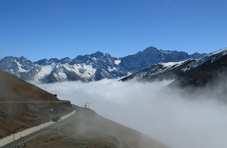
Balangshan View
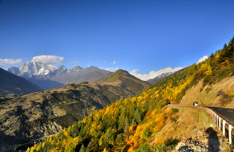
Mount Siguniang from Balang Pass
Today we will have a full day visiting/hiking Shuangqiao Valley of Siguniang. We will first have a short ride from hotel to the base of Shuangqiao and check in to the park. First we will start our visit by a bus ride to the end of valley and start the tour. Around you there are many stunning peaks some are snow-capped and some are big walls including Mt. Jianshan, Mt. Yutu, Mt. Se'erdengpu, Mt. Potala, Mt. Abi and many more. We will walk on the less-walked boardwalk along the river and enjoy some quiet time in nature. We will hike down the valley following the river among the big mountains. The walking is rather flexible with distance since there is bus available along the stops between each location in the valley. The first 3-4 bus stops total 8-12km is where the main views of Shuangqiao are located. The walking will be on well-paved boardwalk on flat terrain with no steep part. Shuangqiaogou Valley is a zigzagged, deep and quiet and the longest valley stretching over 35km. We'll see yaks and forest. By halfway down there is a rafting that we can choose to do. It is also a lot of fun to raft down the calm river for around 20 minutes. Today’s visiti and walking is flexible but we recommend to do the fist 8km at least since it is the most beautiful part of Shuangqiao. After the rafting place there is more to walk. By halfway there may be a couple of kilometers we have to use the road since the boardwalk was flushed away and they may not be fixed. The road is actually fine because there are basically no cars running except the buses which are not many.
After the stop of museum there is no boardwalk so it is the end of hiking. We will then use bus to go out and drive back to hotel.
Hiking 6-8h, easy Pace
Overnight hotel by 3100m

Shuangqiao Valley

Shuangqiao Valley
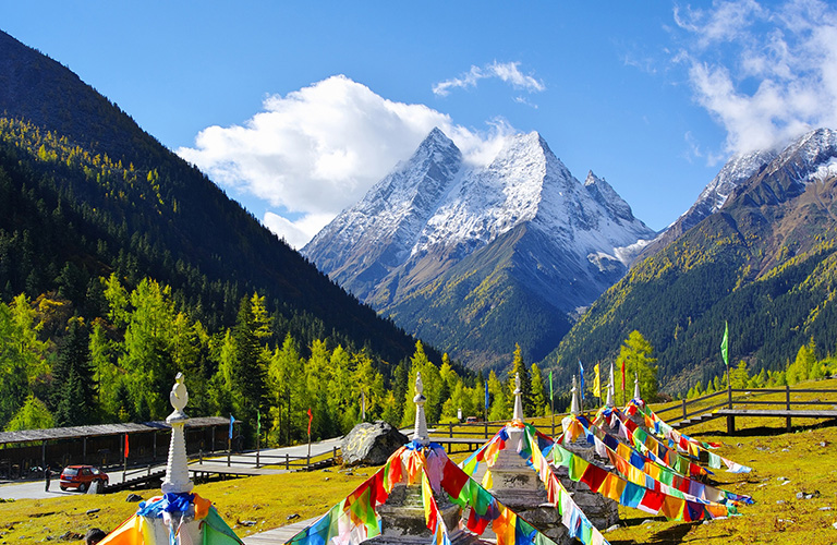
Shuangqiao Valley

Shuangqiao Rafting
Today is our first day of Siguniang to Bipeng Hiking trip. We should leanr how to do proper packing by first night, leave things we don't need by the base and give things we need by nights to the horse. We will first go check in and sign up by the Park Office. This signing up is regulated by the park and it usually takes a long time by around 30 minutes depending on the season. We should have our passport ready for checking. Your guide will do all the checking papers for you but everyone needs to be there. After checking in, we will first use a bus for around 10 minutes to the hiking start point and start to hike.
Changping Valley is one of the three opened valleys (parks) of Mount Siguniang. It is a walking park, no bus is available beyond the first 4km. It is 29-km long valey and visitors need to start from the ticket office by a 10-minute’s bus ride to get to Lama Temple where the walking start. From Lama Temple the walking trail is in forest and on well-paved boardwalks. The walking is rather on gradual terrain with nature around. We will follow the river in the valley and walk by the boardwalk for around 4km to the first stop by Kushutan, a wide part of the river with dead trees and trunks. Then we walk to the 7km point, which is the end of boardwalk called Lower Ganhaizi. From Lower Ganhaizi it is another 3km walking to Muluozi, the big open land by the foot of Mt. Siguniang where views are stunning. All the way we can see at least a big part of Mt. Siguniang.
After arrive by Muluozi, we will set camp and enjoy the beautiful views by this camp: to its east is the big wall of eastface Mt. Siguniang and other side peaks, to its west is Mt. Pomiu and its southeast more peaks, to its north there are more mountains including Mt. Yangmantai and Mt. Camel. It is one of the most beautiful places to camp in Siguniang. At campsite please remember to put on clothes since temperature drops dramatically after sunset and also because the elevation here is higher it will be a lot colder than the base by Rilong. Keep yourself hydrated and always keep your water bottled filled up when possible. Your guide will tell you dinner time and the plans for the next day.
Hiking 10km in 5-6h between 3500m and 3800m, easy Pace
Overnight camping by 3800m
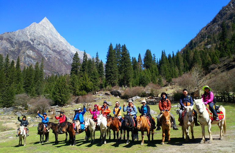
Mount Siguniang Changping Horse-riding

Muluozi Camp
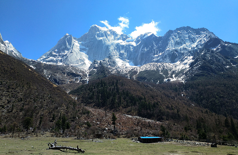
Mount Siguniang Changping Valley
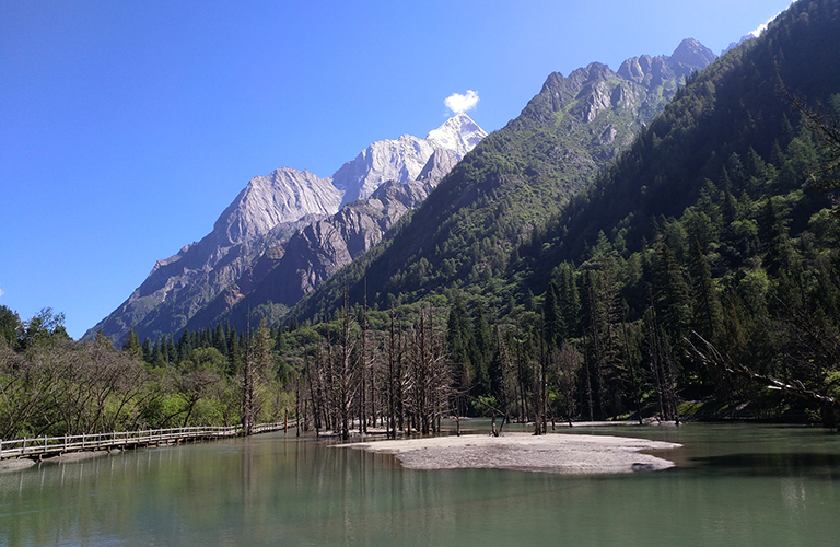
Kushutan
Wake up in the quiet morning at Muluozi and catch the morning glows of Mount Siguniang Yaomei Peak if the weather is clear. Have breakfast prepared by your guide and pack for today's hiking
Today we will continue further into the valley on even more gradual terrain with basically no walking up. Today is a very easy day of hiking. We will walk on mountain trail in the open valley following the river. The walking in total is around 12km. We will see more mountains along the hiking including the north face of Mt. Pomiu, Northeast of Mt. Siguniang, closer look of Mt. Camel and Mt. Yangmantai, Mt. Chibu and westface of Mt. Se'erdengpu. We will arrive camp in afternoon in a nice pine forest by around 3900m. Hiking can be on muddy trail if weather is rainy or snowy.
Today is rather an easy day so we don't have to rush. After arrive camp feel free to walk around the camp if you feel like to walk more. It is one of the wildest parts of Mt. Siguniang Parks that few has been to. Your guide will prepare dinner for you while you relax and prepare for the next day's hard hiking.
Hiking 12km in 5-6h between 3800m and 3900m, easy Pace
Overnight camping by 3900m

Mount Siguniang Hiking

Kazigou Camp

Mount Siguniang Hiking

Hiking Mount Siguniang
Today is the hardest day of hiking. We will wake up early and start before 6am or even 5am. After breakfast we will set up in the dark. The reason to start early is to make sure we have enough time to make to the top if we walk slow. If by normal time we should be able to catch the sunrise by the pass to Bipeng. The walking will start in the dark so we will need to use our headlamp. Sometimes the trail is covered with snow so walking poles are strongly recommended for this part.
First is the most steep part of going up for around 2-3 hours. There is fence built up by the most steep part so we can hold on to the fence to have stops. Horses can not go up so everyone has to walk and there is no option of riding a horse. As we go higher the view becomes brighter and wider. We shall see the big mountains in the central part of Siguniang incluidng the Daogou Mountains. As we ascend over the steep part we will reach an open flat terrain and have great views of the mountains and valleys around. Afterwards it is another shorter ascending but less steep to reach the top of the pass by 4600m.
The pass is usually windy and feels much colder than the base. We will have a break and take some photos by the pass. Looking to its north we shall see the whole valley of Bipeng streching far below our feet. After the break we will start our long descending to the bottom of the valley. Walking up is strenuous while walking down is also strenuous sicne is more tricky and it is also very steep. We need to be very carefull while walking down. We will go from 4600m to the bottom of Bipeng Valley at 3800m, a total of 800m descent.
After arrive by the base, we will use the park car to transfer to the bus station and use the bus to go to the base of the valley and check in to hotel. Have a nice shower and feel free to walk around.
Hiking 8km in 8-9h between 3800m and 4600m, strenuous pace
Overnight camping by 3900m

Daogou Mountains

Above Kaizgou

Mount Siguniang Hiking over the Pass

Bipenggou Valley

Bipeng Landscape

Mt. Yangmantai
Today we will go back to Chengdu. We have an option to go visit Taoping Qiang Village on halfway. In the morning we will start by 1-hour drive to arrive and visit Taoping Qiang Village, a best example of the ancient Qiang wisdom. Taoping Qiang Village is the world's best-preserved inhabited watchtowers and dwellings integrated into a building complex, having the reputation of "natural air-conditioning". Its perfect underground water network, extending passages, and the labyrinth-like architectural art of the unity of towers have been praised by Chinese and foreign scholars as "living fossils of Qiang architectural art" and "mysterious eastern castles". We will have a leisure walk through the village and walk up one of the watchtower to see more open views of the village.
After the visit we will have lunch before continue drive back to Chengdu with a stop and visit to Dujiangyan Irrigation System. Dujiangyan Irrigation System Park is a world heritage sit and a 2000-year-old system that has been working ever since to norish the vast Chengdu Plain. We will visit the core parts of Dyjiangyan Irrigation Park for around 2 hours. After Dujiangyan we will drive back to Chengdu and send you to your hotel. Tour ends.

Taoping Qiang Village
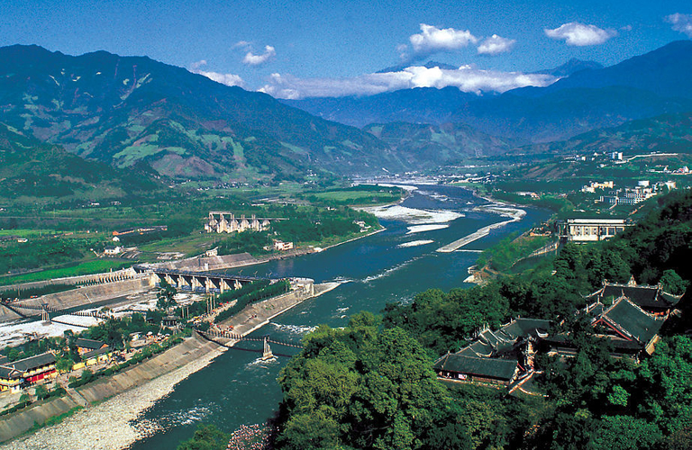
Dujiangyan Irrigation Park
This trip is available from June to November. The other seasons may not be safe to walk over the pass between Changping and Bipeng.
This adventure involves walking at parks and horse trails. So walking boots are necessary for this hiking tour. In this tour, elevation whilst on hiking is between 3200 meters to 4600 meters. Precautions for mountain sickness are necessary as well.
Rain proof and Sun block are also necessary when you are traveling at these places for weather changes quickly at high altitude.
Traveling to the listed places will expect lower standard services at hotels and restaurants even if they maybe the best choices. The service level is not as up to what you have in places like Chengdu. The hotel people don't speak English nor do the people from restaurants. These places are quite far, wild but beautiful. As authenticity comes often with less comfortability. Public Toilet can be really bad. You are always recommended to use your toilet in your hotel while you don't want to use the public toilet or do it in the open wild. You are recommended to have toilet paper with you. Food are with limited options at most of the places. Basically you can find Chinese Food with Sichuan style. On a guided trip you can have them customized into vegetarian or non/less spicy.
This tour involves walking at high altitude at over 3000m, people with cardiac-related conditions, cerebrovascular disease, hypertension, arrhythmia, respiratory diseases, obstructive pulmonary diseases (bronchial asthma, bronchiectasis, emphysema, active tuberculosis, pneumoconiosis), pregnant women and people who have been diagnosed with high altitude pulmonary edema, high altitude cerebral edema, high altitude hypertension, high altitude heart disease, and high altitude polycythemia are not recommended to do this trip.
Please complete belowing form and submit it. Our staffs will contact you as soon as after we receiving your inquiry.